Cruise Information

Inviting Cruise Enterprises to Okinawa

Okinawa is a prefecture consisting of 160 islands. The region benefits from a maritime subtropical climate which brings warm winter weather. Many of the islands are increasingly popular as cruise ports for their rich natural environment and unique traditional culture. We, the Okinawa Convention and Visitors Bureau (OCVB), are engaged in the improvement of the major ports (Naha, Ishigaki, Hirara and Motobu) in the prefecture, to ensure passenger safety at the ports. These ports are becoming important departure points for fly & cruise holidays and island hopping cruises. OCVB aims to encourage major domestic and overseas cruise lines to come to Okinawa through its sales promotions with port governing councils and other supporting organisations.

Inviting Cruise Enterprises to Okinawa

Port Naha

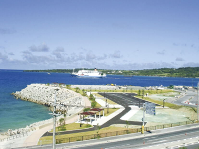
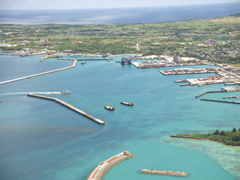
Naha Port, situated between Naha city and Urasoe city, faces the East China Sea and plays a substantial role as a hub for maritime transportation. In 2014, a new cruise ship terminal opened to offer greater convenience for overseas tourists arriving at Naha Port. You can reach the city’s most bustling street “Kokusai Dori” and monorail stations via a 10-minute drive from the port. Shurijo Castle is a 20-minute drive away. You can also take high-speed or regular ferries to the surrounding islands from the ‘Tomarin’ terminal which sits within Naha Port. The Kerama Islands national park is accessible from here as well.

Port Naha
©FROMONE

PORT INFORMATION

PORT NAME Naha Cruise Terminal
LOCATION Wakasa, Naha-City, Okinawa, Japan
PHYSICAL CONSIDERATIONS
Berth
Length / Water depth
340m / -10m
Height of the pier above MLW or chart datum
4.00m
Pier depth (distance to the closest obstruction behind the pier edge)
20m
Minimum depth across the berth
-10m
Channel
Width / water depth
Touguchi Channel
300m / -15m
Turning basin (diameter)
Width / water depth
630m
Clearance
Touguchi Channel’s Air Draft
35m
Maximum tidal range / max currents
Tidal range
HWL+2.12 / LWL+0.04
Currents
9.3cm/s at high tide
16.8cm/s at low tide
Wind & weather conditions / tides by season
0.3- 4.9 m/s (65%) 5-9.9 m/s (34%)
LANDSIDE FACILITIES
Terminal
Terminal Availability
Yes
Shelter or facilities to shelter from rain
Yes
Boarding Bridge
To be completed by the beginning of 2015
CUSTOMS AND IMMIGRATION
Availability of CIQ services and facilities
Permanent
Yes
ACCESS Naha Airport (10-minute drive)
“Kencho-mae” monorail station (15-minute walk)

Port Motobu

“Yanbaru”, the northern region of Okinawa Island, contains a wide range of subtropical nature reserves. This forested area has been home to unique ecosystems since antiquity, and is surrounded by seas of crystal-clear water. Motobu Port is located in the heart of this pristine region. The port gives access to a number of Okinawa’s must-see locations such as the Okinawa Churaumi Aquarium - greeting approximately 2.7 million annual visitors, the Nakijin Castle Ruins - a UNESCO world heritage site, the spectacular ocean views from Kouri Bridge, and the cherry blossoms at Yaedake. The area brims with charm in every season.

Port Motobu
©FROMONE

PORT INFORMATION

PORT NAME Port of Motobu
LOCATION 5235 Aza Sakimotobu, Motobu-Town, Kunigami-gun, Okinawa, Japan
PHYSICAL CONSIDERATIONS
Berth
Length / Water depth
(1)220m / -9.0m
(2)240m / -7.5m
Height of the pier above MLW or chart datum
(1)3.3m
(2)3.3m
Pier depth (distance to the closest obstruction behind the pier edge)
(1)32.5m
(2)32.5m
Minimum depth across the berth
(1)-9.0m
(2)-7.5m
Channel
Width / water depth
(1)300m / -9.0m
(2)300m / -7.5m
Turning basin (diameter)
Width / water depth
(1)560m
(2)560m
Clearance
(1)No limit
(2)No limit
Maximum tidal range / max currents
Tidal range
HHW 3.2m / LLW-0.5m
Wind & weather conditions / tides by season
-
LANDSIDE FACILITIES
Terminal
Terminal Availability
Available
Shelter or facilities to shelter from rain
-
Boarding Bridge
Not Available
CUSTOMS AND IMMIGRATION
Availability of CIQ services and facilities
Permanent
No
Temporary
Yes
ACCESS Naha Airport (120 minutes by car or bus)
Motobu Port bus station (1-minute walk) operated by Okinawa Bus (Motobu Peninsula line, Motobu route)

Port Hirara

Hirara Port, located on Miyako Island (Miyakojima) which lies approximately 300 kilometres southwest of Okinawa Island, is a gateway to the city of Miyakojima administering six islands of various sizes. Hirara is the most developed business and entertainment district in Miyakojima. The island is well known for its crystal-clear water, which attracts scuba divers and other water sports lovers. Athletes looking for a greater challenge would be interested in the iron man competition held here each winter.

Port Hirara
©FROMONE

PORT INFORMATION

PORT NAME Port of Hirara
LOCATION 108-11, Hirarashimosato, Miyakojima-City, Okinawa, Japan
PHYSICAL CONSIDERATIONS
Berth
Length / Water depth
Shimosaki 275m/-10m
Height of the pier above MLW or chart datum
Shimosaki 3.40m
Pier depth (distance to the closest obstruction behind the pier edge)
Shimosaki 100m
Minimum depth across the berth
Shimosaki -10m
Channel
Width / water depth
Shimosaki 250m / -9m
Turning basin (diameter)
Width / water depth
Shimosaki 420m
Clearance
No limit
Maximum tidal range / max currents
Tidal range
HHW 2.67m / LLW-0.42m
Wind & weather conditions / tides by season
-
LANDSIDE FACILITIES
Terminal
Terminal Availability
Not Available
Shelter or facilities to shelter from rain
-
Boarding Bridge
Not Available
CUSTOMS AND IMMIGRATION
Availability of CIQ services and facilities
Permanent
No
Temporary
Yes
ACCESS Miyako Airport (10 minutes by car)
Bus terminal (10 minutes by car)

Port Ishigaki

Ishigaki city is located on the southernmost island of the Japanese archipelago. It is the major urban area of the Yaeyama district, where the scattered islands (including Taketomi, Kohama, Iriomote, Hateruma and Yonaguni) are filled with abundant nature and culture. Ishigaki Port is situated near the city centre. Amenities such as public offices, hotels and commercial complexes are within easy walking distance. The bus terminal and car hire agencies are also located in the neighbourhood. The port has plenty of regular high-speed ferry services to the surrounding islands, making it a tourist hub for sightseeing around the Yaeyama district.

Port Ishigaki
©FROMONE

PORT INFORMATION

PORT NAME Port of Ishigaki
LOCATION 3-4, Hamasaki-cyo, Ishigaki-City, Okinawa, Japan
PHYSICAL CONSIDERATIONS
Berth
Length / Water depth
F Berth 280m/-9.0m
Height of the pier above MLW or chart datum
F Berth 3.40m
Pier depth (distance to the closest obstruction behind the pier edge)
F Berth 50m
Minimum depth across the berth
F Berth -9.10m
Channel
Width / water depth
150m / -9.0m
Turning basin (diameter)
Width / water depth
F Berth Shall discuss with the port authority
Clearance
No limit
Maximum tidal range / max currents
Tidal range
HHW: +1.90m / LLW: +0.10m
Currents
NE 1.0kt at high tide / SW1.0kt at low tide
Wind & weather conditions / tides by season
-
LANDSIDE FACILITIES
Terminal
Terminal Availability
Not Available
Shelter or facilities to shelter from rain
-
Boarding Bridge
Not Available
CUSTOMS AND IMMIGRATION
Availability of CIQ services and facilities
Permanent
No
Temporary
Yes
ACCESS Ishigaki Airport (45 minutes by car or bus)
© Copyright Okinawa Convention & Visitors Bureau All rights Reserved.
Page Arrows